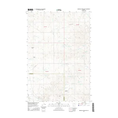
2017 Map of Minnehaha Creek South
USGS Topo · Published 2017About this map
The Little Wolf Mountains dominate the southern landscape of this Treasure and Big Horn County border region, where a network of coulees and seasonal drainages define the topography. In the north, Willoughby Coulee and Dawes Coulee cut through the terrain, feeding into the upper reaches of Minnehaha Cr. This 2017 survey reveals a landscape driven by water access in a semi-arid environment, characterized by an extensive system of numbered springs such as 02N38E06BDCA01 Spring and 02N38E30BBCA01 Spring. These water sources are critical features for the local ranching economy, situated near primary thoroughfares like Horse Creek Rd and Sarpy Rd. The map documents the intricate drainage patterns of Sarpy Cr and the E Fork Sarpy Cr as they weave through the foothills of the southern range.
Find a feature on this map
41 named features on this map. Tap any name to fly to it.
Don’t see what you’re looking for? This feature index may not catch every label — zoom into the map to look around manually.
Map Details
Editions of this 2017 Minnehaha Creek South Map
This is the sole edition of this map. No revisions or reprints were ever made.
Other maps of this area

1954 · Hardin
USGS Topo · 1:250,000

1954 · Forsyth
USGS Topo · 1:250,000

1957 · Hardin
USGS Topo · 1:250,000

1957 · Forsyth
USGS Topo · 1:250,000

1958 · Forsyth
USGS Topo · 1:250,000

1958 · Hardin
USGS Topo · 1:250,000

1971 · Mc Clure Creek
USGS Topo · 1:24,000

1971 · Griffin Coulee SW
USGS Topo · 1:24,000
1971 · Sarpy School
USGS Topo · 1:24,000

1972 · Minnehaha Creek South
USGS Topo · 1:24,000