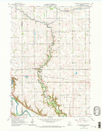
1965 Map of Minnesota Falls
USGS Topo · Published 1967About this map
The confluence of Hawk Creek and the Yellow Medicine River defines this riverine landscape along the border of Chippewa and Renville counties. In the mid-1960s, the area centered on the small settlement of Minnesota Falls, where the Chicago Milwaukee St Paul and Pacific railroad follows the winding path of the Minnesota River. The map illustrates a community anchored by local institutions, such as the Vesper Song Chapel and the Hawk Creek Ch, alongside a rural Townhall. Notable for genealogists and local historians, the sheet includes portions of the Upper Sioux Indian Community and Sioux Agency Twp, reflecting the deep cultural and administrative heritage of the region. Scattered Gravel Pits and a Sandpit indicate the local extractive industry that supported the county's infrastructure during this era.
Find a feature on this map
19 named features on this map. Tap any name to fly to it.
Don’t see what you’re looking for? This feature index may not catch every label — zoom into the map to look around manually.
Map Details
Editions of this 1965 Minnesota Falls Map
2 editions found
Other maps of this area

1953 · New Ulm
USGS Topo · 1:250,000

1957 · New Ulm
USGS Topo · 1:250,000

1958 · New Ulm
USGS Topo · 1:250,000

1962 · Wood Lake
USGS Topo · 1:24,000

1965 · Lone Tree Lake
USGS Topo · 1:24,000

1965 · Asbury
USGS Topo · 1:24,000

1965 · Iverson Lake
USGS Topo · 1:24,000
1965 · Maynard
USGS Topo · 1:24,000
1965 · Clara City
USGS Topo · 1:24,000

1965 · Sacred Heart
USGS Topo · 1:24,000
Featured Places
- Granite Falls, MN
- Minnesota Falls, MN
- Renville County, MN
- Yellow Medicine County, MN
- Chippewa County, MN