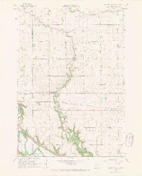
1965 Map of Minnesota Falls
USGS Topo · Published 1967About this map
Hawk Creek snakes through the heart of this mid-1960s landscape, converging with the Minnesota River near the edge of the Upper Sioux Indian Community. The terrain is defined by its water management and agricultural layout, featuring numerous drainage projects like Judicial Ditch Creek and Chetomba Creek. The small settlement of Minnesota Falls serves as a local anchor along the Chicago Milwaukee St Paul and Pacific rail line, which cuts a sharp east-west line across the prairie. Evidence of community life is found in scattered landmarks such as the Vesper Song Chapel, Hawk Creek Ch, and a local Cem. The map captures a moment of established rural infrastructure in Sioux Agency Twp and Wang township, where the economy is reflected in features like the Gravel Pit and Sandpit near the riverbanks.
Find a feature on this map
23 named features on this map. Tap any name to fly to it.
Don’t see what you’re looking for? This feature index may not catch every label — zoom into the map to look around manually.
Map Details
Editions of this 1965 Minnesota Falls Map
2 editions found
Other maps of this area

1953 · New Ulm
USGS Topo · 1:250,000

1957 · New Ulm
USGS Topo · 1:250,000

1958 · New Ulm
USGS Topo · 1:250,000

1962 · Wood Lake
USGS Topo · 1:24,000

1965 · Lone Tree Lake
USGS Topo · 1:24,000

1965 · Asbury
USGS Topo · 1:24,000

1965 · Iverson Lake
USGS Topo · 1:24,000
1965 · Maynard
USGS Topo · 1:24,000
1965 · Clara City
USGS Topo · 1:24,000

1965 · Sacred Heart
USGS Topo · 1:24,000
Featured Places
- Granite Falls, MN
- Minnesota Falls, MN
- Renville County, MN
- Yellow Medicine County, MN
- Chippewa County, MN