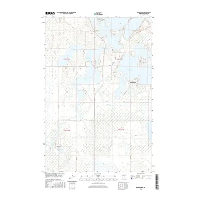
2016 Map of Minnewawa
USGS Topo · Published 2016About this map
Lake Minnewawa and the surrounding Aitkin County wetlands define this landscape, where complex water systems connect the northern Big Sandy Lake to the southern reaches of the Sandy River. The settlement of Minnewawa sits near the eastern shore of its namesake lake, flanked by Dollar Lake and Mud Lake. This area is characterized by a high density of glacial lakes and marshlands, including Rat Lake, Flowage Lake, and Sandy River Lake, which are interconnected by the winding path of Minnewawa Cr and the Sandy River. For those tracing local history or genealogy, the map identifies key community sites such as Shamrock Cem near the Lake Avenue corridor and Lakeview Cem further west. The terrain transitions into a more secluded wetland environment toward the south, where Steamboat Lake, Davis Lake, and Rock Lake appear amidst the extensive drainage network that historically shaped the development of this lake-country region.
Find a feature on this map
65 named features on this map. Tap any name to fly to it.
Don’t see what you’re looking for? This feature index may not catch every label — zoom into the map to look around manually.
Map Details
Editions of this 2016 Minnewawa Map
This is the sole edition of this map. No revisions or reprints were ever made.
Other maps of this area

1953 · Duluth
USGS Topo · 1:250,000

1958 · Duluth
USGS Topo · 1:250,000

1969 · Lawler
USGS Topo · 1:24,000

1970 · Kimberly
USGS Topo · 1:24,000

1970 · Mc Gregor
USGS Topo · 1:24,000

1970 · Tamarack
USGS Topo · 1:24,000

1970 · Palisade
USGS Topo · 1:24,000

1970 · Sanders Lake
USGS Topo · 1:24,000

1970 · Balsam
USGS Topo · 1:24,000

1970 · Libby
USGS Topo · 1:24,000