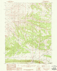
1987 Map of Minnies Gap
USGS Topo · Published 1987About this map
The Glades dominate the southern portion of this high-desert landscape near the Wyoming-Utah border, marking a sharp transition in the local topography. This 1987 provisional survey captures the rugged drainage systems of Washam Wash and the complex network of seasonal flows including Middle Marsh Creek, Jarvies Marsh Creek, and Krause Marsh Creek. For local historians and genealogists, the map identifies the remote Minnies Gap Cemetery and the site of Linwood, providing crucial geographic context for late-20th-century land use in Sweetwater County.
Find a feature on this map
21 named features on this map. Tap any name to fly to it.
Don’t see what you’re looking for? This feature index may not catch every label — zoom into the map to look around manually.
Map Details
Editions of this 1987 Minnies Gap Map
This is the sole edition of this map. No revisions or reprints were ever made.
Other maps of this area

1885 · Ashley
USGS Topo · 1:250,000

1906 · Marsh Peak
USGS Topo · 1:125,000

1908 · Marsh Peak
USGS Topo · 1:125,000

1952 · Dutch John Mtn
USGS Topo · 1:24,000

1952 · Goslin Mtn
USGS Topo · 1:24,000

1952 · Flaming Gorge
USGS Topo · 1:24,000

1954 · Vernal
USGS Topo · 1:250,000

1954 · Rock Springs
USGS Topo · 1:250,000

1957 · Currant Creek Ranch
USGS Topo · 1:62,500

1958 · Vernal
USGS Topo · 1:250,000