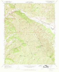
1967 Map of Miranda Pine Mtn
USGS Topo · Published 1969About this map
The Sierra Madre Mountains dominate this high-desert and mountainous landscape of the Los Padres National Forest, where the transition from the Cuyama Valley to steep, ridged terrain is sharply defined by the Cuyama River. Historically, this area represents a blend of public land management and old land grants, evidenced by the Grant Boundary of the Maria Antonia de la Guerra y Lataillade tract. Human presence in this remote terrain is marked by isolated outposts such as Gifford Ranch and Davis Cabins, as well as essential water sources like Miranda Pine Spring and Plowshare Spring. The network of the Sierra Madre Road and the Indians Trail provides the primary access through the steep canyons, including Kerry Canyon and Smith Canyon, linking high points like Miranda Pine Mountain and Porter Peak.
Find a feature on this map
38 named features on this map. Tap any name to fly to it.
Don’t see what you’re looking for? This feature index may not catch every label — zoom into the map to look around manually.
Map Details
Editions of this 1967 Miranda Pine Mtn Map
3 editions found
Other maps of this area

1902 · Santa Ynez
USGS Topo · 1:125,000

1905 · Santa Ynez
USGS Topo · 1:125,000

1905 · Lompoc
USGS Topo · 1:125,000

1912 · McKittrick
USGS Topo · 1:125,000

1937 · Branch Mtn
USGS Topo · 1:48,000

1941 · Caliente Mountain
USGS Topo · 1:62,500

1941 · McPherson Peak
USGS Topo · 1:62,500

1942 · Lompoc
USGS Topo · 1:125,000

1942 · Branch Mountain
USGS Topo · 1:62,500

1942 · Caliente Mtn
USGS Topo · 1:62,500