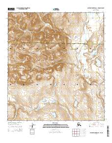
2015 Map of Misheguk Mountain A-1 NE
USGS Topo · Published 2015About this map
The Iggiruk Mountains dominate the central landscape of this wilderness area within the Noatak National Preserve. The geography is defined by its drainage systems, most notably the south-flowing Anisak River and the smaller Itimtikrak Cr, which weave through the high-elevation terrain. This survey illustrates the precise boundary line between the North Slope Borough and the Northwest Arctic Borough, a division that runs across the northern third of the sheet. The lack of any roads, trails, or settlements highlights the isolation of this Arctic environment, where the topographic relief of the Brooks Range remains the primary indicator of the land's character.
Find a feature on this map
9 named features on this map. Tap any name to fly to it.
Don’t see what you’re looking for? This feature index may not catch every label — zoom into the map to look around manually.
Map Details
Editions of this 2015 Misheguk Mountain A-1 NE Map
This is the sole edition of this map. No revisions or reprints were ever made.
Other maps of this area

1951 · Howard Pass
USGS Topo · 1:250,000

1951 · Misheguk Mountain
USGS Topo · 1:250,000

1956 · Howard Pass
USGS Topo · 1:250,000

1956 · Misheguk Mountain
USGS Topo · 1:250,000
1984 · Howard Pass B-5
USGS Topo · 1:63,360
1990 · Misheguk Mountain B-1
USGS Topo · 1:63,360
1990 · Misheguk Mountain A-1
USGS Topo · 1:63,360
1990 · Howard Pass A-5
USGS Topo · 1:63,360
2015 · Howard Pass A-5 SW
USGS Topo · 1:25,000
2015 · Misheguk Mountain A-1 SE
USGS Topo · 1:25,000