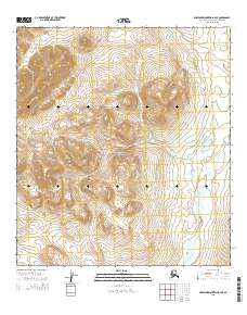
2015 Map of Misheguk Mountain A-4 SE
USGS Topo · Published 2015About this map
Noatak National Preserve encompasses the entirety of this Arctic landscape, defined by its complex hydrology and topographic relief. The terrain is structured by high ridges and drainage basins, most notably the winding course of the Kaluktavik River flowing through the southeastern and southern reaches of the quadrangle. In the northwestern corner, Analuk Cr cuts through the uplands, illustrating the watershed patterns characteristic of the Brooks Range foothills. This 2015 data from the U.S. Geological Survey reflects a wilderness area devoid of permanent human settlements or infrastructure, preserved in its natural state. The map provides precise documentation of the Public Land Survey System boundaries, from t32n r11w down to t30n r9w, which underpin the administrative management of this protected Alaskan corridor.
Find a feature on this map
12 named features on this map. Tap any name to fly to it.
Don’t see what you’re looking for? This feature index may not catch every label — zoom into the map to look around manually.
Map Details
Editions of this 2015 Misheguk Mountain A-4 SE Map
This is the sole edition of this map. No revisions or reprints were ever made.
Other maps of this area

1951 · Baird Mountains
USGS Topo · 1:250,000

1951 · Misheguk Mountain
USGS Topo · 1:250,000

1955 · Baird Mountains D-4
USGS Topo · 1:63,360

1955 · Baird Mountains D-5
USGS Topo · 1:63,360

1955 · Misheguk Mountain A-3
USGS Topo · 1:63,360
1955 · Misheguk Mountain A-4
USGS Topo · 1:63,360

1956 · Misheguk Mountain
USGS Topo · 1:250,000

1956 · Baird Mountains
USGS Topo · 1:250,000

1965 · Baird Mountains
USGS Topo · 1:250,000
2014 · Baird Mountains D-4 NW
USGS Topo · 1:25,000