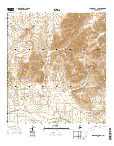
2015 Map of Misheguk Mountain A-4 SW
USGS Topo · Published 2015About this map
The Noatak National Preserve encompasses a vast portion of this Arctic landscape, defined by its complex drainage systems and the formidable presence of the Poktovik Mountains. This 2015 survey reveals an environment where the Noatak River serves as the primary hydrological artery, winding through the southern reaches of the quadrangle. The topography is anchored by Puutik Mtn in the north and the extensive ridges of the Poktovik range to the east, illustrating a classic subarctic alpine terrain. Numerous seasonal and perennial watercourses, including Poktovik Cr, Kugak Cr, and Asiduk Cr, carve through the valleys, showing the intricate watershed patterns required for survival and navigation in this roadless wilderness. The lack of human infrastructure emphasizes the area's status as a protected wilderness, where natural features provide the only landmarks for travelers.
Find a feature on this map
14 named features on this map. Tap any name to fly to it.
Don’t see what you’re looking for? This feature index may not catch every label — zoom into the map to look around manually.
Map Details
Editions of this 2015 Misheguk Mountain A-4 SW Map
This is the sole edition of this map. No revisions or reprints were ever made.
Other maps of this area

1951 · Baird Mountains
USGS Topo · 1:250,000

1951 · Misheguk Mountain
USGS Topo · 1:250,000

1955 · Baird Mountains D-5
USGS Topo · 1:63,360

1955 · Misheguk Mountain A-5
USGS Topo · 1:63,360
1955 · Misheguk Mountain A-4
USGS Topo · 1:63,360

1956 · Misheguk Mountain
USGS Topo · 1:250,000

1956 · Baird Mountains
USGS Topo · 1:250,000

1965 · Baird Mountains
USGS Topo · 1:250,000

2015 · Misheguk Mountain A-4 NE
USGS Topo · 1:25,000
2015 · Misheguk Mountain A-5 SE
USGS Topo · 1:25,000