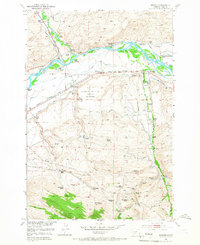
1952 Map of Mission
USGS Topo · Published 1966About this map
The Shields River joins the Yellowstone River in this Montana valley, where the mid-century landscape is defined by an extensive network of irrigation canals like the Palmer Ditch and Pacific Ditch. The dominance of the ranching economy is evident through numerous named holdings, including the Windsor Headquarters Ranch and Mission Ranch. The Northern Pacific railroad tracks parallel the river, connecting these rural outposts. Local governance and social infrastructure are represented by the Sunset County Farm and schools like the Mission Creek School. An interesting moment of transition is captured near the center of the map, where the Livingston Municipal Airport is noted as being under construction. High on the slopes, evidence of earlier settlement patterns persists in the form of the Urback Place (Aban'd) and the Norman Homestead (Aban'd).
Find a feature on this map
62 named features on this map. Tap any name to fly to it.
Don’t see what you’re looking for? This feature index may not catch every label — zoom into the map to look around manually.
Map Details
Editions of this 1952 Mission Map
4 editions found
Other maps of this area

1891 · Livingston
USGS Topo · 1:250,000

1893 · Livingston
USGS Topo · 1:250,000

1947 · Bozeman
USGS Topo · 1:250,000

1948 · Bozeman
USGS Topo · 1:250,000

1951 · Mount Rae
USGS Topo · 1:24,000

1951 · Chadborn
USGS Topo · 1:24,000

1951 · Grannis
USGS Topo · 1:24,000

1951 · Brisbin
USGS Topo · 1:24,000

1951 · Livingston Peak
USGS Topo · 1:24,000

1951 · Hunters Hot Springs
USGS Topo · 1:24,000