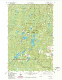
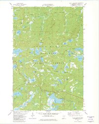
1981 Map of Mitawan Lake
USGS Topo · Published 1985About this map
Superior National Forest and Finland State Forest dominate this northeastern Minnesota landscape, which is defined by a dense network of glacial lakes and river systems. The Little Isabella River meanders through the terrain, connecting to the central Mitawan Lake. The presence of the Environmental Center (USFS) and several specialized recreation paths, such as the Arrowhead Snowmobile Trail and various Ski Trails, points to the area's mid-20th-century development as a hub for managed conservation and outdoor tourism. Notable water bodies like Flat Horn Lake, Steamhaul Lake, and Gegoka Lake provide landmarks for backcountry exploration. Unlike more developed regions, the human footprint here is largely limited to infrastructure for forestry and recreation, including the Little Isabella River Campground and scattered Gravel Pits used for local road maintenance.
Find a feature on this map
41 named features on this map. Tap any name to fly to it.
Don’t see what you’re looking for? This feature index may not catch every label — zoom into the map to look around manually.
Map Details
Editions of this 1981 Mitawan Lake Map
2 editions found
Other maps of this area

1954 · Greenwood Lake
USGS Topo · 1:62,500

1954 · Two Harbors
USGS Topo · 1:250,000

1955 · Isabella
USGS Topo · 1:62,500

1957 · Two Harbors
USGS Topo · 1:250,000

1957 · Gabbro Lake
USGS Topo · 1:62,500

1958 · Two Harbors
USGS Topo · 1:250,000

1964 · Two Harbors
USGS Topo · 1:250,000
1981 · Gabbro Lake
USGS Topo · 1:24,000
1981 · Isabella
USGS Topo · 1:24,000
1981 · Slate Lake East
USGS Topo · 1:24,000