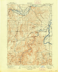
1906 Map of Mitchell Butte
USGS Topo · Published 1948About this map
Vale and the confluence of the Malheur River and Bully Creek anchor the northern landscape of this early twentieth-century survey along the Oregon-Idaho border. The mapping by Gilbert Young and S. T. Penick reveals an intricate network of irrigation vital to the region's agricultural development, including the Farmers Ditch, Vine's Ditch, and the Gillerman and Richter Canal. This infrastructure transformed the arid Big Sage Flats near Nyssa and Owyhee, facilitating early settlement. To the south, the terrain becomes increasingly complex, dominated by Grassy Mountain and the deep incision of the Owyhee River at Hole in the Ground. Family holdings such as Isaacs Ranch and Prices Ranch are visible along Sucker Creek, while landmarks like Graveyard Point and Mitchell Butte provided navigational waypoints for travelers in this remote corner of Malheur County.
Find a feature on this map
70 named features on this map. Tap any name to fly to it.
Don’t see what you’re looking for? This feature index may not catch every label — zoom into the map to look around manually.
Map Details
Editions of this 1906 Mitchell Butte Map
3 editions found
Other maps of this area

1892 · Silver City
USGS Topo · 1:125,000

1894 · Silver City
USGS Topo · 1:125,000

1897 · Weiser
USGS Topo · 1:125,000

1898 · Nampa
USGS Topo · 1:125,000

1898 · Silver City
USGS Topo · 1:125,000

1906 · Mitchell Butte
USGS Topo · 1:125,000

1950 · Jamieson
USGS Topo · 1:62,500

1951 · Malheur Butte
USGS Topo · 1:24,000

1951 · Moores Hollow
USGS Topo · 1:62,500

1951 · Payette
USGS Topo · 1:24,000