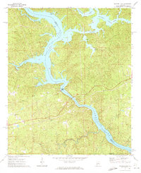
1971 Map of Mitchell Dam
USGS Topo · Published 1973About this map
Powerplant Mitchell Dam stands as the central landmark of this 1970s landscape, where the Coosa River is harnessed for hydroelectric power. The impounded waters create the complex, branch-like shorelines of Mitchell Lake and Jordan Lake, which define the borders of Chilton, Coosa, and Elmore counties. The surrounding hillsides are marked by the presence of rural infrastructure, such as the Clanton Pumping Station and a prominent Radio Tower, alongside established local meeting places.
Find a feature on this map
27 named features on this map. Tap any name to fly to it.
Don’t see what you’re looking for? This feature index may not catch every label — zoom into the map to look around manually.
Map Details
Editions of this 1971 Mitchell Dam Map
2 editions found
Other maps of this area

1891 · Clanton
USGS Topo · 1:125,000

1901 · Wetumpka
USGS Topo · 1:125,000

1903 · Wetumpka
USGS Topo · 1:125,000

1953 · Montgomery
USGS Topo · 1:250,000

1956 · Montgomery
USGS Topo · 1:250,000

1957 · Montgomery
USGS Topo · 1:250,000

1959 · Billingsley
USGS Topo · 1:62,500

1959 · Elmore
USGS Topo · 1:62,500

1971 · Richville
USGS Topo · 1:24,000
1971 · Mitchell Dam NW
USGS Topo · 1:24,000