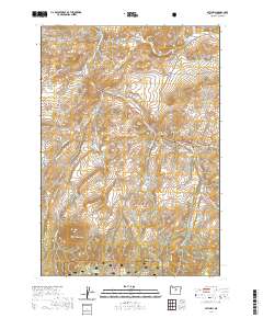
2020 Map of Mitchell
USGS Topo · Published 2020About this map
The town of Mitchell serves as a central hub in this high-desert landscape of Wheeler County, where the topography is defined by prominent volcanic remnants and a complex network of canyons and draws. This 2020 edition provides a detailed view of the local drainage patterns led by Bridge Cr and its tributaries like Gable Cr and Nelson Cr. The southern portion of the map transitions into the Ochoco National Forest, marked by the elevations of the Ochoco Mountains. Genealogists and local historians can find specifically named sites including the Mitchell Cem and Lower Mitchell Cem, while landmarks such as Sargent Butte, Bailey Butte, and White Butte illustrate the region's distinctive geology. Strategic water management for the arid environment is evidenced by the presence of Nelson Reservoir, Paynes Pond, and the Dollarhide Pond, as well as named irrigation features like Hall Ditch and Shoemaker Ditch.
Find a feature on this map
40 named features on this map. Tap any name to fly to it.
Don’t see what you’re looking for? This feature index may not catch every label — zoom into the map to look around manually.
Map Details
Editions of this 2020 Mitchell Map
This is the sole edition of this map. No revisions or reprints were ever made.
Other maps of this area

1926 · Mitchell
USGS Topo · 1:125,000

1951 · Lookout Mtn
USGS Topo · 1:62,500

1955 · Bend
USGS Topo · 1:250,000

1957 · Bend
USGS Topo · 1:250,000

1958 · Bend
USGS Topo · 1:250,000

1966 · Peterson Point
USGS Topo · 1:24,000

1966 · Mt. Pisgah
USGS Topo · 1:24,000

1966 · Mitchell
USGS Topo · 1:62,500

1968 · Painted Hills
USGS Topo · 1:24,000

1968 · Lawson Mtn
USGS Topo · 1:24,000