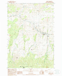
1988 Map of Mitchell
USGS Topo · Published 1988About this map
The town of Mitchell serves as the focal point of this high-desert landscape in central Oregon, situated along the banks of Bridge Creek. This 1980s survey illustrates a rural community supported by a mix of public lands and ranching infrastructure, including the Ochoco National Forest and the Bridge Creek Wilderness. Significant local landmarks include the Mitchell Reservoir and the Dollarhide Pond, which are critical water sources in this arid environment. The map details various industrial and service sites such as a Landing Strip, a Sanitary Disposal Site, and several Gravel Pits, alongside prominent terrain features like Sargent Butte and Juniper Butte. For those researching family history, the Cem near the town center and named locations like Meyers and Nelson provide important localized context for 20th-century land use and settlement patterns.
Find a feature on this map
34 named features on this map. Tap any name to fly to it.
Don’t see what you’re looking for? This feature index may not catch every label — zoom into the map to look around manually.
Map Details
Editions of this 1988 Mitchell Map
This is the sole edition of this map. No revisions or reprints were ever made.
Other maps of this area

1926 · Mitchell
USGS Topo · 1:125,000

1951 · Lookout Mtn
USGS Topo · 1:62,500

1955 · Bend
USGS Topo · 1:250,000

1957 · Bend
USGS Topo · 1:250,000

1958 · Bend
USGS Topo · 1:250,000

1966 · Peterson Point
USGS Topo · 1:24,000

1966 · Mt. Pisgah
USGS Topo · 1:24,000

1966 · Mitchell
USGS Topo · 1:62,500

1968 · Painted Hills
USGS Topo · 1:24,000

1968 · Lawson Mtn
USGS Topo · 1:24,000