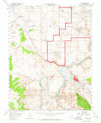
1959 Map of Moab
USGS Topo · Published 1965About this map
Moab serves as the focal point of this survey, situated at the bend of the Colorado River where the river's path is carved through geologic formations like The Portal. This mid-century view, created during the uranium boom, shows the Ore Reduction Plant and nearby industrial infrastructure such as the Sewage Disposal and Gaging Sta. The landscape is a mix of agricultural potential in Spanish Valley and the beginning of modern tourism at Arches National Monument, where landmarks like Balanced Rock and the Double Arch are clearly defined.
Find a feature on this map
89 named features on this map. Tap any name to fly to it.
Don’t see what you’re looking for? This feature index may not catch every label — zoom into the map to look around manually.
Map Details
Editions of this 1959 Moab Map
3 editions found
Other maps of this area

1885 · La Sal
USGS Topo · 1:250,000

1951 · The Knoll
USGS Topo · 1:62,500

1951 · Upheaval Dome
USGS Topo · 1:62,500

1952 · Moab 4 NW
USGS Topo · 1:24,000

1952 · Moab 3 NE
USGS Topo · 1:24,000

1952 · Moab 3 SE
USGS Topo · 1:24,000

1952 · Carlisle 2 NE
USGS Topo · 1:24,000

1952 · Moab 4 SW
USGS Topo · 1:24,000

1954 · Mt Peale 2 NW
USGS Topo · 1:24,000

1954 · Carlisle 1 NE
USGS Topo · 1:24,000