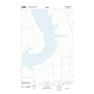
2012 Map of Mobridge NE
USGS Topo · Published 2012About this map
Lake Oahe dominates the Missouri River valley in this region of South Dakota, where the reservoir’s expansive waters fill the ancient channel and its tributaries. The landscape is defined by the sharp, dendritic inlets created as the lake flooded several stream beds, most notably Mad Bear Cr in the northwest and Locke Cr to the east. Along the western banks, Leola River Pl traces the shoreline, while the eastern plateau is organized by a strictly rectilinear road grid including 297th Ave and 120th St. In the southern portion of the map, Highway 1804 provides the primary transit route through the area, crossing near the drainage of Cane Cr. The contrast between the irregular, water-carved western bluffs and the orderly agricultural layout of the eastern prairie captures the distinct geography of the Missouri Plateau.
Find a feature on this map
12 named features on this map. Tap any name to fly to it.
Don’t see what you’re looking for? This feature index may not catch every label — zoom into the map to look around manually.
Map Details
Editions of this 2012 Mobridge NE Map
This is the sole edition of this map. No revisions or reprints were ever made.
Other maps of this area

1953 · McIntosh
USGS Topo · 1:250,000

1958 · McIntosh
USGS Topo · 1:250,000

1965 · Herreid SW
USGS Topo · 1:24,000

1965 · Pollock SE
USGS Topo · 1:24,000

1966 · Kenel
USGS Topo · 1:24,000

1967 · Glenham
USGS Topo · 1:24,000

1967 · Selby SW
USGS Topo · 1:24,000

1967 · Mobridge NE
USGS Topo · 1:24,000

1967 · Mobridge NW
USGS Topo · 1:24,000

1967 · Mobridge
USGS Topo · 1:24,000