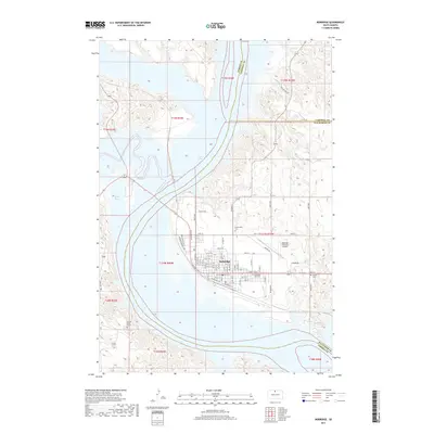
2017 Map of Mobridge
USGS Topo · Published 2017About this map
Mobridge stands as the central hub on the eastern bluffs overlooking the expansive Lake Oahe in Walworth County. This survey illustrates the town's grid and its orientation toward the Missouri River, with residential and commercial corridors such as Park View Blvd and Kennedy Memorial Dr defining the local geography. The map documents several significant cultural and local history sites, most notably Sitting Bull's Grave located on the western side of the water, a site of deep historical importance. Within the town and its immediate outskirts, genealogists will find Greenwood Cemetery, Mobridge City Cemetery, and Grace Cemetery, while the northern area reveals the transition into Campbell and Corson counties. Modern infrastructure, including the Mobridge Municipal Airport and a network of rural routes like Flying W Road, shows the area's continued role as a regional waypoint.
Find a feature on this map
28 named features on this map. Tap any name to fly to it.
Don’t see what you’re looking for? This feature index may not catch every label — zoom into the map to look around manually.
Map Details
Editions of this 2017 Mobridge Map
This is the sole edition of this map. No revisions or reprints were ever made.
Other maps of this area

1953 · McIntosh
USGS Topo · 1:250,000

1956 · Wakpala SE
USGS Topo · 1:24,000

1956 · Wakpala
USGS Topo · 1:24,000

1958 · McIntosh
USGS Topo · 1:250,000

1967 · Glenham
USGS Topo · 1:24,000

1967 · Mobridge NE
USGS Topo · 1:24,000

1967 · Mobridge NW
USGS Topo · 1:24,000

1967 · Mobridge
USGS Topo · 1:24,000

1968 · Moreau NW
USGS Topo · 1:24,000

1968 · Moreau NE
USGS Topo · 1:24,000