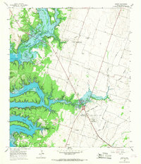
1965 Map of Moffat
USGS Topo · Published 1968About this map
The rising waters of Belton Reservoir dominate the landscape of Bell County in the mid-1960s, creating an intricate shoreline around Tweedle Mountain and Morgans Point. This survey captures the transition of the Leon River valley into a major water resource, where former terrestrial landmarks like Jubilee Springs and various creek confluences meet the expanded lake. The map documents rural life through the presence of the Moffat Sch and multiple family and community burial grounds, including the Moffat Cem, White Hall Cem, and St Pauls Cemetery. In the southeastern corner, the Temple Corporate Boundary edges toward the Draughon-Miller Airport, signaling the regional growth of nearby Temple. Unique cultural sites of the era are also noted, such as the Sunset Speedway and the youth camp at Camp Kachina.
Find a feature on this map
37 named features on this map. Tap any name to fly to it.
Don’t see what you’re looking for? This feature index may not catch every label — zoom into the map to look around manually.
Map Details
Editions of this 1965 Moffat Map
3 editions found
Other maps of this area

1892 · Temple
USGS Topo · 1:125,000

1894 · Gatesville
USGS Topo · 1:125,000

1924 · Gatesville 4-d
USGS Topo · 1:48,000

1924 · Gatesville 4-a
USGS Topo · 1:48,000

1924 · Temple 2-C
USGS Topo · 1:48,000

1924 · Temple 3-C
USGS Topo · 1:48,000

1924 · Temple 3-B
USGS Topo · 1:48,000

1930 · Killeen
USGS Topo · 1:62,500

1931 · Mc Gregor
USGS Topo · 1:62,500

1931 · Belton
USGS Topo · 1:62,500