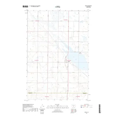
2018 Map of Moffit
USGS Topo · Published 2018About this map
Moffit serves as the focal point of this prairie landscape, situated near the western edge of Long Lake. The settlement is organized around Main St and Moffit Rd, reflecting a grid-based development typical of the North Dakota plains. The terrain is defined by its extensive wetland complexes and glacial depressions, with Moffit Butte rising as a prominent landmark north of the lake. To the south of the village, the Moffit Cem remains a significant site for local genealogical research. This map captures the intersection of the Burleigh Co Emmons Co boundary line, illustrating the rural infrastructure of the region through its systematic network of section-line roads such as 314th St SE and 115th Ave SE.
Find a feature on this map
26 named features on this map. Tap any name to fly to it.
Don’t see what you’re looking for? This feature index may not catch every label — zoom into the map to look around manually.
Map Details
Editions of this 2018 Moffit Map
This is the sole edition of this map. No revisions or reprints were ever made.
Other maps of this area

1951 · McKenzie
USGS Topo · 1:62,500

1951 · Driscoll
USGS Topo · 1:62,500

1954 · Bismarck
USGS Topo · 1:250,000

1958 · Bismarck
USGS Topo · 1:250,000

1971 · Moffit SW
USGS Topo · 1:24,000

1971 · Moffit SE
USGS Topo · 1:24,000

1971 · Moffit NW
USGS Topo · 1:24,000

1971 · Moffit
USGS Topo · 1:24,000

1975 · McKenzie
USGS Topo · 1:24,000

1975 · Sterling
USGS Topo · 1:24,000