
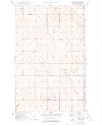
1949 Map of Mohall SW
USGS Topo · Published 1949About this map
Little Deep Creek meanders through this portion of Renville County, carving a subtle path across a landscape defined by the rural townships of Hamerly and Hamlet. At the time of this 1948 topography survey, the area was organized around a network of local institutions, including St Johns Church and Hamerly Ch, which served as social and spiritual anchors for the farming community. The map reveals a highly structured system of education typical of the mid-century Northern Plains, with numbered schoolhouses like School No 1 through School No 5 distributed systematically across the sections. These specific locations offer essential coordinates for genealogists tracing family land or researchers studying the historical distribution of rural public works before the consolidation of North Dakota's school districts.
Find a feature on this map
10 named features on this map. Tap any name to fly to it.
Don’t see what you’re looking for? This feature index may not catch every label — zoom into the map to look around manually.
Map Details
Editions of this 1949 Mohall SW Map
2 editions found
Other maps of this area

1947 · Tolley
USGS Topo · 1:62,500

1948 · Mohall
USGS Topo · 1:24,000

1948 · Tolley
USGS Topo · 1:24,000

1949 · Mohall NE
USGS Topo · 1:24,000

1949 · Sherwood
USGS Topo · 1:24,000

1949 · Greene
USGS Topo · 1:24,000

1949 · Grano NE
USGS Topo · 1:24,000

1949 · Mouse River Park NE
USGS Topo · 1:24,000

1949 · Mouse River Park
USGS Topo · 1:24,000

1950 · Tolley
USGS Topo · 1:62,500