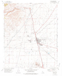
1973 Map of Mojave
USGS Topo · Published 1984About this map
Mojave Airport dominates the eastern flats of this Kern County landscape, serving as a focal point for the region's aviation and transport infrastructure. The town of Mojave itself is a critical junction where the Southern Pacific and Atchison Topeka and Santa Fe railroads converge, illustrating the area's historical role as a desert transit hub. To the north, the Los Angeles Aqueduct cuts across the terrain near the Horned Toad Hills, highlighting the massive engineering efforts required to move water through this arid environment. Local life is centered around institutions like Joshua Sch and the Mojave East Park, while the southern end of the sheet reveals industrial activity at Standard Hill and the small siding at Fleta. The map also captures numerous prospects and gravel pits, signifying the ongoing mineral extraction that shaped the local economy.
Find a feature on this map
43 named features on this map. Tap any name to fly to it.
Don’t see what you’re looking for? This feature index may not catch every label — zoom into the map to look around manually.
Map Details
Editions of this 1973 Mojave Map
2 editions found
Other maps of this area

1915 · Elizabeth Lake
USGS Topo · 1:125,000

1915 · Mojave
USGS Topo · 1:125,000

1917 · Elizabeth Lake
USGS Topo · 1:125,000

1943 · Rosamond
USGS Topo · 1:62,500

1943 · Tehachapi
USGS Topo · 1:62,500

1943 · Mojave
USGS Topo · 1:62,500

1943 · Willow Springs
USGS Topo · 1:62,500

1947 · Plano
USGS Topo · 1:24,000

1947 · Mojave
USGS Topo · 1:24,000
1947 · Bissell
USGS Topo · 1:24,000