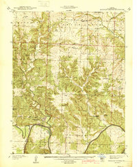
1940 Map of Monegaw Springs
USGS Topo · Published 1940About this map
Monegaw Springs and the surrounding river bluffs define this 1938 landscape in St. Clair County, where the Osage River winds past Youngers Lookout. The map reveals a densely settled rural community before the mid-century shifts in agricultural and social patterns, evidenced by the numerous district schools and local houses of worship that anchored the area. From Kidds Chapel in the north to the Benton Green Sch in the south, the region was subdivided into distinct neighborhoods like Chalk Level and Center. Local history is preserved through numerous family-named landmarks and cemeteries, including Terry Cem and Yeater Cem, while the rugged hills are broken by waterways such as Gallinipper Creek and Little Monegaw Creek. The presence of a Pumping Station near the northern boundary hints at the infrastructure supporting these clustered settlements during the pre-war era.
Find a feature on this map
38 named features on this map. Tap any name to fly to it.
Don’t see what you’re looking for? This feature index may not catch every label — zoom into the map to look around manually.
Map Details
Editions of this 1940 Monegaw Springs Map
2 editions found
Other maps of this area

1886 · Stockton
USGS Topo · 1:125,000

1887 · Clinton
USGS Topo · 1:125,000

1894 · Clinton
USGS Topo · 1:125,000

1937 · Tiffin
USGS Topo · 1:31,680

1938 · Monegaw Springs
USGS Topo · 1:24,000

1938 · Roscoe
USGS Topo · 1:24,000

1938 · Vista
USGS Topo · 1:24,000

1938 · Taberville
USGS Topo · 1:24,000

1939 · Osceola
USGS Topo · 1:24,000

1940 · Taberville
USGS Topo · 1:24,000