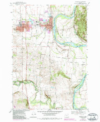
1970 Map of Monmouth
USGS Topo · Published 1987About this map
The Willamette River meanders along the eastern edge of this landscape, defining the fertile lowlands of the American Bottom and providing a natural border between Polk and Marion counties. The neighboring towns of Monmouth and Independence serve as the primary hubs, where the presence of the College of Education and the Southern Pacific rail line highlights a regional focus on academia and transport.
Find a feature on this map
50 named features on this map. Tap any name to fly to it.
Don’t see what you’re looking for? This feature index may not catch every label — zoom into the map to look around manually.
Map Details
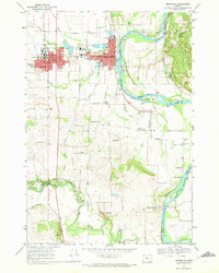
Editions of this 1970 Monmouth Map
2 editions found
Other maps of this area

1912 · Jefferson
USGS Topo · 1:31,680

1913 · Wells
USGS Topo · 1:31,680

1914 · Independence
USGS Topo · 1:31,680

1914 · Soap Creek
USGS Topo · 1:31,680

1915 · Rickreall
USGS Topo · 1:31,680

1915 · Eola
USGS Topo · 1:31,680

1915 · Sidney
USGS Topo · 1:31,680

1916 · Albany
USGS Topo · 1:62,500

1917 · Salem
USGS Topo · 1:62,500

1921 · Corvallis
USGS Topo · 1:62,500