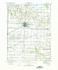
1921 Map of Monmouth
USGS Topo · Published 1981About this map
The city of Monmouth serves as the central hub of this 1920s landscape, where a dense concentration of educational and social institutions defines the early 20th-century character of Warren County. The map reveals an incredible density of rural schools, such as Farmers Academy, Hickory College, and Science Hall School, illustrating the localized nature of education before the era of district consolidation. A complex web of rail lines, including the Chicago Burlington and Quincy and the Atchison Topeka and Santa Fe, bisects the agricultural grid, connecting smaller rail stops like Kirkwood, Eleanor, and Ponemah.
Find a feature on this map
77 named features on this map. Tap any name to fly to it.
Don’t see what you’re looking for? This feature index may not catch every label — zoom into the map to look around manually.
Map Details
Editions of this 1921 Monmouth Map
3 editions found
Other maps of this area

1915 · Avon
USGS Topo · 1:62,500

1916 · Good Hope
USGS Topo · 1:62,500

1918 · La Harpe
USGS Topo · 1:62,500

1918 · Good Hope
USGS Topo · 1:62,500

1921 · Monmouth
USGS Topo · 1:62,500

1923 · Monmouth
USGS Topo · 1:62,500

1923 · Alexis
USGS Topo · 1:62,500

1925 · Alexis
USGS Topo · 1:62,500

1925 · Galesburg
USGS Topo · 1:62,500

1927 · Galesburg
USGS Topo · 1:62,500