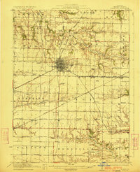
1923 Map of Monmouth
USGS Topo · Published 1923About this map
Monmouth serves as a bustling rail center on this 1923 survey, where the Chicago Burlington and Quincy RR and the Minneapolis and St Louis RR intersect. The landscape is intensely divided by the Public Land Survey System, showing a dense grid of rural education that includes uniquely named institutions like Hickory College, Farmer's Academy, and Science Hall School. This network of small district schools, such as Coonville School and Locust Grove School, reflects the high population density of the Illinois prairie before the consolidation of rural school districts. Along the watercourses of Henderson Creek and Cedar Creek, the terrain breaks into more complex topography, contrasting with the flat agricultural uplands where settlements like Kirkwood, Coldbrook, and Berwick are positioned along the primary rail lines. The inclusion of the County Farm near the city center provides a look at the social infrastructure of early 20th-century Warren County.
Find a feature on this map
77 named features on this map. Tap any name to fly to it.
Don’t see what you’re looking for? This feature index may not catch every label — zoom into the map to look around manually.
Map Details
Editions of this 1923 Monmouth Map
2 editions found
Other maps of this area

1915 · Avon
USGS Topo · 1:62,500

1916 · Good Hope
USGS Topo · 1:62,500

1918 · La Harpe
USGS Topo · 1:62,500

1918 · Good Hope
USGS Topo · 1:62,500

1921 · Monmouth
USGS Topo · 1:62,500

1923 · Monmouth
USGS Topo · 1:62,500

1923 · Alexis
USGS Topo · 1:62,500

1925 · Alexis
USGS Topo · 1:62,500

1925 · Galesburg
USGS Topo · 1:62,500

1927 · Galesburg
USGS Topo · 1:62,500