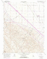
1955 Map of Monocline Ridge
USGS Topo · Published 1972About this map
Monocline Ridge dominates this 1955 survey area, defining a stark landscape where the arid slopes of the Tumey Hills meet the intensive agricultural engineering of the Central Valley. The map captures a critical period of infrastructure development, featuring the California Aqueduct and the Chaney Pumping Station, markers of the massive state water projects of the mid-20th century. High elevations like Ciervo Hill transition into the valley floor, where a rigid grid of roads including South Avenue and Manning Avenue organizes the terrain.
Find a feature on this map
19 named features on this map. Tap any name to fly to it.
Don’t see what you’re looking for? This feature index may not catch every label — zoom into the map to look around manually.
Map Details
Editions of this 1955 Monocline Ridge Map
4 editions found

Other maps of this area

1912 · Coalinga
USGS Topo · 1:125,000

1913 · Panoche
USGS Topo · 1:125,000

1915 · Priest Valley
USGS Topo · 1:125,000

1921 · Tierra Loma School
USGS Topo · 1:31,680

1922 · Tufts Ranch
USGS Topo · 1:31,680

1922 · Chaney Ranch
USGS Topo · 1:31,680

1923 · Levis
USGS Topo · 1:31,680

1923 · Tierra Loma School
USGS Topo · 1:31,680

1923 · Monocline Ridge
USGS Topo · 1:31,680

1943 · New Idria
USGS Topo · 1:62,500