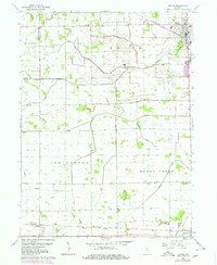
1962 Map of Monon
USGS Topo · Published 1980About this map
Monon serves as a central junction for the Louisville and Nashville railroad in this mid-century portrait of White County. The landscape is defined by an extensive network of drainage infrastructure, including the Mc Killip Ditch and Hoagland Ditch, which supported the conversion of this territory into productive farmland. To the south, the town of Reynolds sits at the intersection of the primary north-south rail line and the Toledo Peoria and Western tracks, while the small community of Seafield marks the southwestern reach of the survey. Family and community history are preserved in several locations, from the Monon Cem and Palestine Cem near the larger settlements to the isolated Swisher Cem found along the banks of Honey Creek. The presence of industrial Storage Bins near the tracks highlights the importance of the rail system in moving the region's agricultural output.
Find a feature on this map
33 named features on this map. Tap any name to fly to it.
Don’t see what you’re looking for? This feature index may not catch every label — zoom into the map to look around manually.
Map Details
Editions of this 1962 Monon Map
2 editions found
Other maps of this area

1953 · Danville
USGS Topo · 1:250,000

1955 · Danville
USGS Topo · 1:250,000

1956 · Danville
USGS Topo · 1:250,000

1962 · Monticello South
USGS Topo · 1:24,000

1962 · Templeton NE
USGS Topo · 1:24,000

1962 · Monon NE
USGS Topo · 1:24,000

1962 · Brookston NW
USGS Topo · 1:24,000

1962 · Monon
USGS Topo · 1:24,000

1962 · Monticello North
USGS Topo · 1:24,000
1962 · Francesville
USGS Topo · 1:24,000