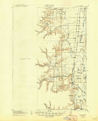
1922 Map of Monroe
USGS Topo · Published 1947About this map
Monroe and the surrounding Willamette Valley landscape are defined by a network of meandering waterways and emerging rail lines during this early 20th-century survey. The Long Tom River and Muddy Creek snake through the valley floor, creating a complex system of sloughs and lakes like Hulbert Lake and Harkens Lake. These natural features dictated the placement of small rural communities and local schools, such as the Belknap School and the Irish Bend School.
Find a feature on this map
53 named features on this map. Tap any name to fly to it.
Don’t see what you’re looking for? This feature index may not catch every label — zoom into the map to look around manually.
Map Details
Editions of this 1922 Monroe Map
4 editions found

Other maps of this area

1909 · Harrisburg
USGS Topo · 1:31,680

1909 · Elmira
USGS Topo · 1:62,500

1910 · Eugene
USGS Topo · 1:62,500

1911 · Monroe
USGS Topo · 1:31,680

1911 · Inavale
USGS Topo · 1:31,680

1912 · Halsey
USGS Topo · 1:62,500

1913 · Philomath
USGS Topo · 1:31,680

1913 · Oakville
USGS Topo · 1:31,680

1916 · Albany
USGS Topo · 1:62,500

1921 · Corvallis
USGS Topo · 1:62,500