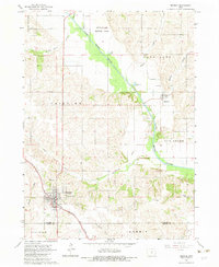
1965 Map of Monroe
USGS Topo · Published 1983About this map
Monroe serves as the primary hub of activity in this mid-1960s survey, where the Chicago Rock Island and Pacific railroad tracks bisect the town near the Monroe Cem and Gifford Cem. The landscape transition is evident where the grid of the town meets the meandering South Skunk River, which flows past the Riverview Honor Farm and through the timbered areas of Palo Alto and Elk Creek. To the north, the smaller settlement of Reasnor is captured just before modern highway expansions reached the area, as evidenced by a nearby road marked under construction. This map preserves the locations of several country institutions, including Tools Chapel and the Warren Grove Sch, alongside remnant infrastructure like an Old Railroad Grade near Buck Creek.
Find a feature on this map
37 named features on this map. Tap any name to fly to it.
Don’t see what you’re looking for? This feature index may not catch every label — zoom into the map to look around manually.
Map Details
Editions of this 1965 Monroe Map
2 editions found

Other maps of this area

1909 · Knoxville
USGS Topo · 1:62,500

1910 · Pella
USGS Topo · 1:62,500

1912 · Knoxville
USGS Topo · 1:62,500

1912 · Pella
USGS Topo · 1:62,500

1954 · Des Moines
USGS Topo · 1:250,000

1956 · Des Moines
USGS Topo · 1:250,000

1957 · Des Moines
USGS Topo · 1:250,000

1965 · Prairie City
USGS Topo · 1:24,000

1965 · Newton
USGS Topo · 1:24,000

1965 · Knoxville NW
USGS Topo · 1:24,000