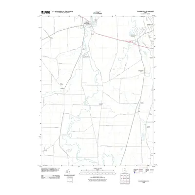
2010 Map of Monroeville
USGS Topo · Published 2010About this map
The West Branch Huron River meanders through the central Huron County landscape, anchoring a network of small agricultural settlements and historic parish grounds. The village of Monroeville sits at the northern bend of the river, marked by the Monroeville Post Office and the nearby Monroeville Low Head Dam. This area is particularly dense with community landmarks that speak to generations of local families, from the large Saint Alphonsus Catholic Cemetery to smaller, distinctively named sites like the Axe Factory Cemetery.
Find a feature on this map
59 named features on this map. Tap any name to fly to it.
Don’t see what you’re looking for? This feature index may not catch every label — zoom into the map to look around manually.
Map Details
Editions of this 2010 Monroeville Map
This is the sole edition of this map. No revisions or reprints were ever made.
Other maps of this area

1901 · Bellevue
USGS Topo · 1:62,500

1903 · Bellevue
USGS Topo · 1:62,500

1904 · Sandusky
USGS Topo · 1:62,500

1915 · Norwalk
USGS Topo · 1:62,500

1915 · Siam
USGS Topo · 1:62,500

1944 · Norwalk
USGS Topo · 1:62,500

1956 · Toledo
USGS Topo · 1:250,000

1959 · Kimball
USGS Topo · 1:24,000

1959 · Milan
USGS Topo · 1:24,000
1959 · Bellevue
USGS Topo · 1:24,000