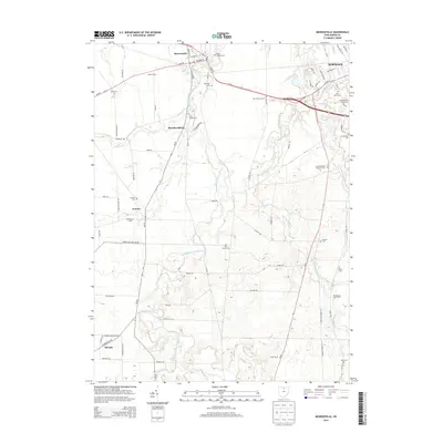
2013 Map of Monroeville
USGS Topo · Published 2013About this map
Monroeville sits at the junction of the West Branch Huron River and the East Branch Huron River, serving as a central hub for this portion of Huron County. The landscape is a mix of small agricultural hamlets and established family operations like Martin Farms and the Shield Dairy Farm. These rural settlements, including Standardsburg and Pontiac, are connected by a network of state routes and county roads that follow the meandering paths of Frink Run and Sandhill Cr. In the northeastern corner, the edge of Norwalk introduces more concentrated development, including the Huron County Fairgrounds. The area is notably dense with historical burial grounds, ranging from large denominational sites like Saint Alphonsus Catholic Cem and Saint Pauls Cem to smaller, local sites such as Axe Factory Cem and Hester Cem, providing significant touchpoints for local genealogical research.
Find a feature on this map
81 named features on this map. Tap any name to fly to it.
Don’t see what you’re looking for? This feature index may not catch every label — zoom into the map to look around manually.
Map Details
Editions of this 2013 Monroeville Map
This is the sole edition of this map. No revisions or reprints were ever made.
Other maps of this area

1901 · Bellevue
USGS Topo · 1:62,500

1903 · Bellevue
USGS Topo · 1:62,500

1904 · Sandusky
USGS Topo · 1:62,500

1915 · Norwalk
USGS Topo · 1:62,500

1915 · Siam
USGS Topo · 1:62,500

1944 · Norwalk
USGS Topo · 1:62,500

1956 · Toledo
USGS Topo · 1:250,000

1959 · Kimball
USGS Topo · 1:24,000

1959 · Milan
USGS Topo · 1:24,000
1959 · Bellevue
USGS Topo · 1:24,000