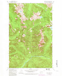
1965 Map of Monte Cristo
USGS Topo · Published 1982About this map
Monte Cristo sits high in the North Cascades, serving as a focal point for this 1960s survey that was photorevised in the early 1980s. The map documents a landscape defined by its mining heritage and demanding geography, noting the historic locations of Mineral City and Galena. These sites reflect the boom-and-bust cycles of the region's mineral extraction era, now contained within the Mt Baker Snoqualmie National Forest. High-altitude water bodies such as Silver Lake, Foggy Lake, and Twin Lakes are scattered among prominent summits like Del Campo Peak and Gothic Peak. Drainage patterns are clearly marked, with the South Fork Sauk River flowing north and the North Fork Skykomish River winding through the southern portion. For researchers, the transition from active mining settlements to designated historical sites is visible through labels like Seventysix Gulch and Poodle Dog Pass, which once hummed with prospectors and pack trains.
Find a feature on this map
45 named features on this map. Tap any name to fly to it.
Don’t see what you’re looking for? This feature index may not catch every label — zoom into the map to look around manually.
Map Details
Editions of this 1965 Monte Cristo Map
5 editions found

Other maps of this area

1899 · Glacier Peak
USGS Topo · 1:125,000

1899 · Stillaguamish
USGS Topo · 1:125,000

1901 · Glacier Peak
USGS Topo · 1:125,000

1901 · Stilaguamish
USGS Topo · 1:125,000

1902 · Skykomish
USGS Topo · 1:125,000

1905 · Skykomish
USGS Topo · 1:125,000

1921 · Sultan
USGS Topo · 1:125,000

1923 · Sultan
USGS Topo · 1:125,000

1955 · Concrete
USGS Topo · 1:250,000

1957 · Silverton
USGS Topo · 1:62,500