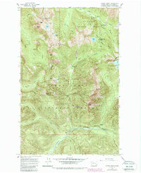
1965 Map of Monte Cristo
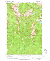
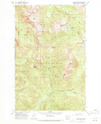
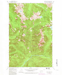
USGS Topo · Published 1988About this map
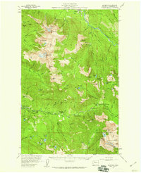
Monte Cristo serves as the focal point for this survey of the high Cascade Range, marking a storied mining district at the headwaters of the South Fork Sauk River. The map illustrates a landscape where industrial history and mountain geography are inextricably linked, evidenced by former mining hubs like Mineral City and Galena. These sites are reached via rugged routes such as the Monte Cristo Trail, which traverses the high passes between the Mt Baker National Forest and Snoqualmie National Forest. High-altitude basins and jagged summits, including Del Campo Peak and Silvertip Peak, surround deep alpine waters like Silver Lake and Foggy Lake. The drainage patterns show the divide between northern and southern watersheds, with the North Fork Skykomish River carving through the southern reaches of the quadrangle.
Find a feature on this map
45 named features on this map. Tap any name to fly to it.
Don’t see what you’re looking for? This feature index may not catch every label — zoom into the map to look around manually.
Map Details
Editions of this 1965 Monte Cristo Map
5 editions found

Other maps of this area

1899 · Glacier Peak
USGS Topo · 1:125,000

1899 · Stillaguamish
USGS Topo · 1:125,000

1901 · Glacier Peak
USGS Topo · 1:125,000

1901 · Stilaguamish
USGS Topo · 1:125,000

1902 · Skykomish
USGS Topo · 1:125,000

1905 · Skykomish
USGS Topo · 1:125,000

1921 · Sultan
USGS Topo · 1:125,000

1923 · Sultan
USGS Topo · 1:125,000

1955 · Concrete
USGS Topo · 1:250,000
1957 · Silverton
USGS Topo · 1:62,500