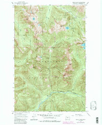
1965 Map of Monte Cristo
USGS Topo · Published 1988About this map
Monte Cristo stands as the central hub of this high-alpine landscape, captured during a mid-1960s field check with later Forest Service updates. The geography is defined by the sharp divide between the Mt Baker National Forest and Snoqualmie National Forest, where the headwaters of the South Fork Sauk River and North Fork Skykomish River originate. The presence of Mineral City (Site) and Galena (Site) points to the area's transition from a late-19th-century mining district to a rugged recreation area. High-altitude landmarks like Poodle Dog Pass and Silver Lake neighbor steep drainages such as Seventysix Gulch, illustrating the difficult terrain that once challenged prospectors. Further south, the Troublesome Creek drainage meets the Skykomish River near a Gaging Station, marking the lower elevations of this complex mountain terrain.
Find a feature on this map
44 named features on this map. Tap any name to fly to it.
Don’t see what you’re looking for? This feature index may not catch every label — zoom into the map to look around manually.
Map Details
Editions of this 1965 Monte Cristo Map
5 editions found

Other maps of this area

1899 · Glacier Peak
USGS Topo · 1:125,000

1899 · Stillaguamish
USGS Topo · 1:125,000

1901 · Glacier Peak
USGS Topo · 1:125,000

1901 · Stilaguamish
USGS Topo · 1:125,000

1902 · Skykomish
USGS Topo · 1:125,000

1905 · Skykomish
USGS Topo · 1:125,000

1921 · Sultan
USGS Topo · 1:125,000

1923 · Sultan
USGS Topo · 1:125,000

1955 · Concrete
USGS Topo · 1:250,000

1957 · Silverton
USGS Topo · 1:62,500