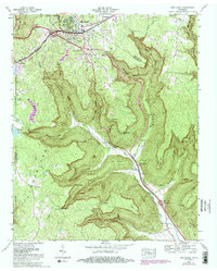
1974 Map of Monteagle
USGS Topo · Published 1983About this map
Monteagle sits atop the plateau at the junction of Grundy and Marion counties, where modern interstate infrastructure overlays a landscape of deep limestone coves and steep escarpments. The town's development is marked by landmarks like the Athletic field, several water tanks, and a Silo, while the surrounding terrain is defined by dramatic drop-offs such as Eagle Cliff and Payne View. The Louisville And Nashville railroad corridor, including the Sand Switch siding, traces the western edge of the plateau before the land breaks into the complex drainage of Ladd Cove and Gizzard Cove. Rural life is anchored by family-named burial grounds like Trussell Cem and Dyer Cem, alongside local congregations at St Johns Ch and Jumpoff Ch. South of the main settlement, the land descends toward Martin Springs, where Battle Creek carves a path through the valley floor, creating a stark contrast between the high plateau communities and the lower cove settlements.
Find a feature on this map
80 named features on this map. Tap any name to fly to it.
Don’t see what you’re looking for? This feature index may not catch every label — zoom into the map to look around manually.
Map Details
Editions of this 1974 Monteagle Map
3 editions found
Other maps of this area

1895 · Sewanee
USGS Topo · 1:125,000

1936 · Sewanee
USGS Topo · 1:24,000

1936 · Alto
USGS Topo · 1:24,000

1936 · Orme
USGS Topo · 1:24,000

1936 · Sinking Cove
USGS Topo · 1:24,000

1936 · Burrow Cove
USGS Topo · 1:24,000

1936 · Tracy City
USGS Topo · 1:24,000

1936 · Monteagle
USGS Topo · 1:24,000

1936 · White City
USGS Topo · 1:24,000
1936 · South Pittsburg
USGS Topo · 1:24,000