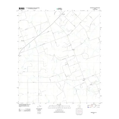
2013 Map of Monteola
USGS Topo · Published 2013About this map
Monteola and Zunkerville anchor this South Texas landscape where the local economy and geography are defined by a network of seasonal watercourses and rural industry. The terrain is marked by the winding paths of Medio Cr, Sulphur Cr, and Dry Medio Cr, which traverse the open country between small crossroads communities. At Caesar, the industrial footprint of the Caesar Oil Field contrasts with the quiet presence of the Pullin -Livingston Cem, providing a clear focal point for genealogists and local historians tracking family roots in Karnes County. The map traces a grid of secondary routes, including the prominent Countyline Rd, which historically separated land holdings and local jurisdictions. Farther north, the settlement of Bainville sits near the headwaters of the creek system, illustrating the dispersed settlement pattern characteristic of this ranching and oil-producing region.
Find a feature on this map
49 named features on this map. Tap any name to fly to it.
Don’t see what you’re looking for? This feature index may not catch every label — zoom into the map to look around manually.
Map Details
Editions of this 2013 Monteola Map
This is the sole edition of this map. No revisions or reprints were ever made.
Other maps of this area
1931 · Falls City
USGS Topo · 1:62,500
1936 · Pettus
USGS Topo · 1:62,500

1953 · Crystal City
USGS Topo · 1:250,000
1953 · Beeville
USGS Topo · 1:250,000

1955 · Crystal City
USGS Topo · 1:250,000
1956 · Suniland
USGS Topo · 1:62,500
1956 · Beeville
USGS Topo · 1:250,000
1956 · Pettus
USGS Topo · 1:62,500
1956 · Karnes City
USGS Topo · 1:62,500
1960 · Beeville
USGS Topo · 1:250,000