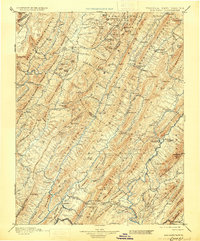
1901 Map of Monterey
USGS Topo · Published 1930About this map
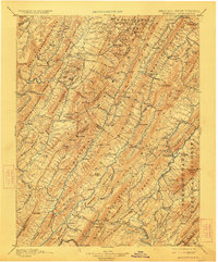
Monterey serves as the focal point of this highland region, situated at the intersection of mountain passes during the late nineteenth-century survey period. The landscape is defined by the steep, parallel ridges of the Alleghenies, including Jack Mountain and Monterey Mountain, which dictate the narrow corridors of settlement. Water-powered industry and mountain agriculture are evident through labels like Cleeks Mills and Williamsville, while the region's early reputation as a therapeutic retreat is anchored by Warm Springs and Bath Alum Springs in the south. The distribution of small settlements like New Hampden and Valley Center illustrates a society closely tied to the valleys of the Jackson River and Bullpasture River. This survey captures the area before modern highway development, highlighting the significance of gaps like Vanderpool Gap for travel and commerce between Virginia and West Virginia.
Find a feature on this map
150 named features on this map. Tap any name to fly to it.
Don’t see what you’re looking for? This feature index may not catch every label — zoom into the map to look around manually.
Map Details
Editions of this 1901 Monterey Map
8 editions found

Other maps of this area

1887 · Lewisburg
USGS Topo · 1:125,000

1889 · Beverly
USGS Topo · 1:125,000

1891 · Lewisburg
USGS Topo · 1:125,000

1891 · Huntersville
USGS Topo · 1:125,000

1892 · Beverly
USGS Topo · 1:125,000

1892 · Franklin
USGS Topo · 1:125,000

1893 · Buckhannon
USGS Topo · 1:125,000

1894 · Huntersville
USGS Topo · 1:125,000

1894 · Staunton
USGS Topo · 1:125,000

1894 · Natural Bridge
USGS Topo · 1:125,000