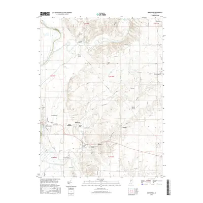
2016 Map of Montezuma
USGS Topo · Published 2016About this map
Sugar Creek and the Wabash River define the northern and western reaches of this Parke County landscape, where several historic crossings remain preserved. In the northern section, the West Union Bridge spans the water near the settlement of West Union, while further south, the Sim Smith Bridge and Phillips Bridge cross the drainage of Leatherwood Creek. The area is dotted with small, long-standing communities such as Montezuma, Bloomingdale, and Annapolis, linked by a grid of rural routes like 10 O'Clock Rd. Genealogists will find numerous burial grounds scattered across the terrain, including the Oakland Cem on the outskirts of Montezuma, and more secluded locations like Arabia Cem and Hethcoe Cem. The map provides a detailed look at the rural drainage network, showing how Big Raccoon Creek winds past Armiesburg before joining the Wabash valley.
Find a feature on this map
95 named features on this map. Tap any name to fly to it.
Don’t see what you’re looking for? This feature index may not catch every label — zoom into the map to look around manually.
Map Details
Editions of this 2016 Montezuma Map
This is the sole edition of this map. No revisions or reprints were ever made.
Other maps of this area

1948 · Wallace
USGS Topo · 1:24,000

1951 · Clinton
USGS Topo · 1:24,000

1951 · Mecca
USGS Topo · 1:24,000

1952 · Catlin
USGS Topo · 1:24,000

1953 · Indianapolis
USGS Topo · 1:250,000

1955 · Rockville
USGS Topo · 1:24,000

1955 · Kingman
USGS Topo · 1:24,000

1955 · Montezuma
USGS Topo · 1:24,000

1955 · Dana
USGS Topo · 1:24,000
1955 · Newport
USGS Topo · 1:24,000