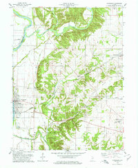
1978 Map of Montezuma
USGS Topo · Published 1978About this map
The Wabash River and Sugar Creek converge in this corner of Western Indiana, shaping a landscape defined by fertile bottomlands and industrial activity. Montezuma sits prominently along the riverbank, serving as a focal point for local transport where the Baltimore and Ohio Railroad crosses the water. To the east, the settlement of Bloomingdale is surrounded by evidence of the area's geological economy, including kilns, claypits, and several gravel pits.
Find a feature on this map
43 named features on this map. Tap any name to fly to it.
Don’t see what you’re looking for? This feature index may not catch every label — zoom into the map to look around manually.
Map Details
Editions of this 1978 Montezuma Map
This is the sole edition of this map. No revisions or reprints were ever made.
Other maps of this area

1948 · Wallace
USGS Topo · 1:24,000

1951 · Clinton
USGS Topo · 1:24,000

1951 · Mecca
USGS Topo · 1:24,000

1952 · Catlin
USGS Topo · 1:24,000

1953 · Indianapolis
USGS Topo · 1:250,000

1955 · Rockville
USGS Topo · 1:24,000

1955 · Kingman
USGS Topo · 1:24,000

1955 · Montezuma
USGS Topo · 1:24,000

1955 · Dana
USGS Topo · 1:24,000
1955 · Newport
USGS Topo · 1:24,000