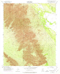
1952 Map of Montezuma Peak
USGS Topo · Published 1978About this map
The Sierra Estrella dominates this landscape, rising sharply from the desert floor along the border of Maricopa and Pinal counties. Much of the eastern terrain lies within the Gila River Indian Reservation, where the Santa Cruz Wash and Vekol Wash converge as they move toward the Gila River. Human activity is concentrated along the river valley and the foothills, evidenced by St Catherines Ch and a nearby Cem. The map reveals a history of resource extraction tucked into the northern ridges, where a Mica Quarry and several Prospects or individual Prospect sites mark the slopes. Agricultural infrastructure is visible in the northeast through the Hoover Ditch, while the peaks themselves carry evocative names such as Montezuma Peak, Montezumas Head, and Montezuma Sleeping, reflecting the cultural significance of these prominent landforms.
Find a feature on this map
20 named features on this map. Tap any name to fly to it.
Don’t see what you’re looking for? This feature index may not catch every label — zoom into the map to look around manually.
Map Details
Editions of this 1952 Montezuma Peak Map
3 editions found

Other maps of this area

1912 · Phoenix
USGS Topo · 1:62,500

1913 · Maricopa
USGS Topo · 1:62,500

1914 · Phoenix
USGS Topo · 1:62,500

1915 · Maricopa
USGS Topo · 1:62,500

1946 · Avondale
USGS Topo · 1:62,500

1948 · Cashion
USGS Topo · 1:62,500

1951 · Mobile
USGS Topo · 1:62,500

1952 · Maricopa
USGS Topo · 1:24,000

1952 · Lone Butte
USGS Topo · 1:24,000

1952 · Laveen
USGS Topo · 1:24,000