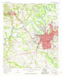
1958 Map of Montgomery
USGS Topo · Published 1968About this map
The Alabama River anchors this 1950s-era survey, winding from the industrial north past Prattville toward the dense state capital. The map details a period of significant military and institutional presence, featuring both Maxwell Air Force Base and Gunter Air Force Base, alongside the State Capitol and Alabama State College. The landscape is characterized by a transition from the urban grid of Montgomery to the surrounding rural reaches of Autauga and Montgomery counties.
Find a feature on this map
113 named features on this map. Tap any name to fly to it.
Don’t see what you’re looking for? This feature index may not catch every label — zoom into the map to look around manually.
Map Details
Editions of this 1958 Montgomery Map
2 editions found

Other maps of this area

1891 · Clanton
USGS Topo · 1:125,000

1901 · Wetumpka
USGS Topo · 1:125,000

1901 · Wetumpka
USGS Topo · 1:62,500

1903 · Wetumpka
USGS Topo · 1:125,000

1927 · Montgomery
USGS Topo · 1:48,000

1930 · Montgomery
USGS Topo · 1:62,500

1953 · Montgomery
USGS Topo · 1:250,000

1956 · Montgomery
USGS Topo · 1:250,000

1957 · Montgomery
USGS Topo · 1:250,000

1957 · Letohatchee
USGS Topo · 1:62,500