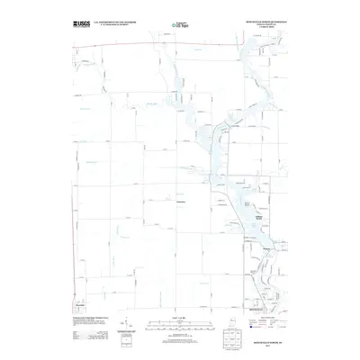
2013 Map of Monticello North
USGS Topo · Published 2013About this map
The Tippecanoe River carves a distinctive path through this White County landscape, widening into Lake Shafer and Lake Freeman. These water bodies serve as the focal point for local development, notably at the Indiana Beach amusement area and the residential clusters of Isle of Homes and Norway. The map reveals a transition from the dense, recreational shorelines of Big Monon Bay and Honey Creek Bay to the expansive, gridded agricultural lands to the west.
Find a feature on this map
144 named features on this map. Tap any name to fly to it.
Don’t see what you’re looking for? This feature index may not catch every label — zoom into the map to look around manually.
Map Details
Editions of this 2013 Monticello North Map
This is the sole edition of this map. No revisions or reprints were ever made.
Other maps of this area

1953 · Danville
USGS Topo · 1:250,000

1955 · Danville
USGS Topo · 1:250,000

1956 · Danville
USGS Topo · 1:250,000

1962 · Buffalo
USGS Topo · 1:24,000

1962 · Monticello South
USGS Topo · 1:24,000

1962 · Monon NE
USGS Topo · 1:24,000

1962 · Brookston NW
USGS Topo · 1:24,000

1962 · Monon
USGS Topo · 1:24,000

1962 · Monticello North
USGS Topo · 1:24,000
1962 · Francesville
USGS Topo · 1:24,000