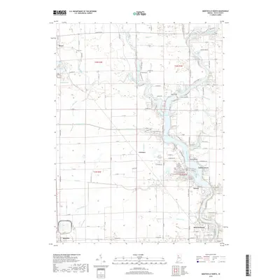
2019 Map of Monticello North
USGS Topo · Published 2019About this map
The Tippecanoe River corridor dominates this White County landscape, forming a complex water system that includes Lake Freeman, Big Monon Bay, and Honey Creek Bay. This network of inlets and peninsulas, including the Isle of Homes, supports the recreation-focused community at Indiana Beach. Historically, the settlement pattern is defined by the intersection of rail and agriculture, with Monon and Reynolds serving as peripheral hubs connected by the TP&W RR. The interior township lines of t27n r4w and t28n r3w are heavily dissected by a drainage network of named channels like McKillip Ditch and Hancock Ditch, illustrating the intensive land management required for local farming. Smaller residential clusters and family burial grounds like Wilson Cem and Hughes Cem are scattered across the plains between the river and the rail lines.
Find a feature on this map
112 named features on this map. Tap any name to fly to it.
Don’t see what you’re looking for? This feature index may not catch every label — zoom into the map to look around manually.
Map Details
Editions of this 2019 Monticello North Map
This is the sole edition of this map. No revisions or reprints were ever made.
Other maps of this area

1953 · Danville
USGS Topo · 1:250,000

1955 · Danville
USGS Topo · 1:250,000

1956 · Danville
USGS Topo · 1:250,000

1962 · Buffalo
USGS Topo · 1:24,000

1962 · Monticello South
USGS Topo · 1:24,000

1962 · Monon NE
USGS Topo · 1:24,000

1962 · Brookston NW
USGS Topo · 1:24,000

1962 · Monon
USGS Topo · 1:24,000

1962 · Monticello North
USGS Topo · 1:24,000
1962 · Francesville
USGS Topo · 1:24,000