
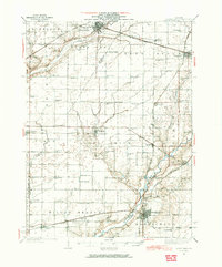
1937 Map of Monticello
USGS Topo · Published 1937About this map
The Sangamon River meanders through the southeast corner of this Central Illinois landscape, anchoring a region defined by an intensive network of early 20th-century transportation and rural education. Several major rail lines, including the Illinois Central Railroad and the Illinois Terminal Railroad, crisscross the territory, connecting hubs like Monticello and Farmer City. This survey represents the height of the district school system, documenting a dense grid of one-room schoolhouses such as Sunny Mound Sch, Victory Sch, and Prairie View Sch spaced every few miles to serve the surrounding farmsteads. Smaller settlements like White Heath and De Land appear alongside water management features like Wolf Run Ditch, reflecting the ongoing modification of the Goose Creek drainage for agricultural productivity.
Find a feature on this map
72 named features on this map. Tap any name to fly to it.
Don’t see what you’re looking for? This feature index may not catch every label — zoom into the map to look around manually.
Map Details
Editions of this 1937 Monticello Map
2 editions found
Other maps of this area

1907 · Mahomet
USGS Topo · 1:62,500

1928 · Gibson City
USGS Topo · 1:62,500

1929 · Decatur
USGS Topo · 1:62,500

1933 · Decatur
USGS Topo · 1:62,500

1943 · Monticello
USGS Topo · 1:62,500

1950 · Tuscola
USGS Topo · 1:62,500

1951 · Le Roy
USGS Topo · 1:62,500

1952 · Arrowsmith
USGS Topo · 1:62,500

1955 · Bement
USGS Topo · 1:62,500

1957 · Gibson City
USGS Topo · 1:62,500