
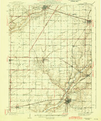
1943 Map of Monticello
USGS Topo · Published 1943About this map
Monticello serves as the regional anchor in this mid-century portrait of Central Illinois, where the Sangamon River meanders through a landscape defined by industrial rail lines and agricultural townships. The dual influence of the Wabash and Illinois Central railroads is evident, dictating the growth of smaller hubs like Farmer City, Mansfield, and De Land. The map reveals a dense network of early rural infrastructure, specifically noted by the high concentration of neighborhood schoolhouses such as Champion Sch, Weedman Sch, and Victory Sch that once served the outlying farms of Nixon and Goose Creek. Genealogists will find particular value in the precisely marked locations of local landmarks like Kentucky Ch and Fullerton Ch, alongside family-named burial grounds including Mc Cord Cem and Greenleaf Cem.
Find a feature on this map
83 named features on this map. Tap any name to fly to it.
Don’t see what you’re looking for? This feature index may not catch every label — zoom into the map to look around manually.
Map Details
Editions of this 1943 Monticello Map
2 editions found
Other maps of this area

1907 · Mahomet
USGS Topo · 1:62,500

1928 · Gibson City
USGS Topo · 1:62,500

1929 · Decatur
USGS Topo · 1:62,500

1933 · Decatur
USGS Topo · 1:62,500

1937 · Monticello
USGS Topo · 1:48,000

1950 · Tuscola
USGS Topo · 1:62,500

1951 · Le Roy
USGS Topo · 1:62,500

1952 · Arrowsmith
USGS Topo · 1:62,500

1955 · Bement
USGS Topo · 1:62,500

1957 · Gibson City
USGS Topo · 1:62,500