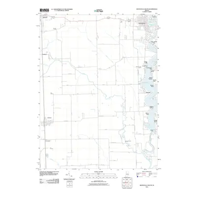
2010 Map of Monticello South
USGS Topo · Published 2010About this map
Lake Freeman dominates the eastern edge of this landscape, its shoreline dense with residential developments and seasonal retreats like Gingrich Addition, Scarlet Oaks, and Sandy Beach. The water, held by the Oakdale Dam on the Tippecanoe River, represents the transition from the river's natural course to a managed recreational corridor. Away from the water, the terrain is defined by a grid of agricultural drainage, including the Snow Ditch and Big Creek, supporting the towns of Reynolds, Chalmers, and the smaller settlement at Smithson. Genealogists will find several burial sites preserved among the fields, such as Bunnell Cemetery and the Harvey and Phebus Cemetery. The presence of the White County Airport and the expanding footprint of Monticello reflect the area's role as a regional hub for both infrastructure and lakeside living.
Find a feature on this map
71 named features on this map. Tap any name to fly to it.
Don’t see what you’re looking for? This feature index may not catch every label — zoom into the map to look around manually.
Map Details
Editions of this 2010 Monticello South Map
This is the sole edition of this map. No revisions or reprints were ever made.
Other maps of this area

1953 · Danville
USGS Topo · 1:250,000

1955 · Danville
USGS Topo · 1:250,000

1956 · Danville
USGS Topo · 1:250,000

1962 · Brookston SW
USGS Topo · 1:24,000

1962 · Monticello South
USGS Topo · 1:24,000

1962 · Brookston NW
USGS Topo · 1:24,000

1962 · Monon
USGS Topo · 1:24,000

1962 · Delphi
USGS Topo · 1:24,000

1962 · Monticello North
USGS Topo · 1:24,000
1962 · Yeoman
USGS Topo · 1:24,000