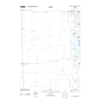
2013 Map of Monticello South
USGS Topo · Published 2013About this map
Lake Freeman and the Tippecanoe River define the eastern edge of this landscape, where recreational communities such as C and C Beach, Sandy Beach, and Scarlet Oaks line the water south of Monticello. The map documents a dense network of specialized drainage ditches, including Snow Ditch, Diener Ditch, and Emge Ditch, which reveal the extensive hydrological management required to maintain the agricultural productivity of White County. Moving west from the river, the terrain transitions into the grid-patterned farmlands surrounding Chalmers and Reynolds. These settlements, along with Smithson, serve as local hubs for a landscape marked by rural infrastructure, including the White County Airport and a system of county roads that stitch together small developments like Gingrich Addition and Richey Park.
Find a feature on this map
118 named features on this map. Tap any name to fly to it.
Don’t see what you’re looking for? This feature index may not catch every label — zoom into the map to look around manually.
Map Details
Editions of this 2013 Monticello South Map
This is the sole edition of this map. No revisions or reprints were ever made.
Other maps of this area

1953 · Danville
USGS Topo · 1:250,000

1955 · Danville
USGS Topo · 1:250,000

1956 · Danville
USGS Topo · 1:250,000

1962 · Brookston SW
USGS Topo · 1:24,000

1962 · Monticello South
USGS Topo · 1:24,000

1962 · Brookston NW
USGS Topo · 1:24,000

1962 · Monon
USGS Topo · 1:24,000

1962 · Delphi
USGS Topo · 1:24,000

1962 · Monticello North
USGS Topo · 1:24,000
1962 · Yeoman
USGS Topo · 1:24,000