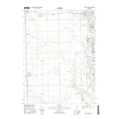
2016 Map of Monticello South
USGS Topo · Published 2016About this map
The Tippecanoe River corridor south of Monticello defines this portion of White County, where the impounded waters of Lake Freeman create a distinct recreational and residential landscape. Numerous lakeside developments such as Golden Hill, Cedar Point, and Breezy Point line the eastern shore, contrasting with the expansive agricultural flatlands to the west. This agricultural interior is drained by an extensive network of man-made waterways, including Snow Ditch, Diener Ditch, and Schroeder Ditch, which support the rural farmsteads found between the rail-oriented settlements of Reynolds and Chalmers. Genealogists will find several notable burial sites throughout the townships, including Bunnell Cem near the northern boundary and High Cem further south. The map illustrates the transition from the concentrated grid of East Monticello to the dispersed hamlets like Smithson, providing a clear view of how water access and drainage shaped the region's development.
Find a feature on this map
95 named features on this map. Tap any name to fly to it.
Don’t see what you’re looking for? This feature index may not catch every label — zoom into the map to look around manually.
Map Details
Editions of this 2016 Monticello South Map
This is the sole edition of this map. No revisions or reprints were ever made.
Other maps of this area

1953 · Danville
USGS Topo · 1:250,000

1955 · Danville
USGS Topo · 1:250,000

1956 · Danville
USGS Topo · 1:250,000

1962 · Brookston SW
USGS Topo · 1:24,000

1962 · Monticello South
USGS Topo · 1:24,000

1962 · Brookston NW
USGS Topo · 1:24,000

1962 · Monon
USGS Topo · 1:24,000

1962 · Delphi
USGS Topo · 1:24,000

1962 · Monticello North
USGS Topo · 1:24,000
1962 · Yeoman
USGS Topo · 1:24,000