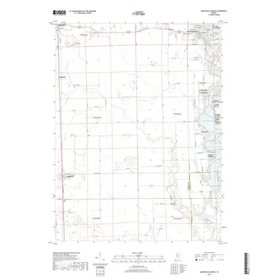
2019 Map of Monticello South
USGS Topo · Published 2019About this map
Lake Freeman and the Tippecanoe River define the eastern edge of this Indiana landscape, where recreational developments like Walnut Gardens and Gingrich Addition line the waterfront. Further west, the terrain transitions into a strictly organized agricultural grid, marked by a system of drainage including Big Creek and Emge Ditch. This 2019 survey documents the enduring layout of rural communities like Chalmers and Reynolds, which serve as anchors for the surrounding farmsteads. Local history is preserved in a network of small burial grounds scattered across the townships, such as Saint Joseph Cem near the northern boundary and the Harvey and Phiebus Cem located near the White County and Carroll County line. The map captures the interface between the established agricultural interior and the more densely settled summer communities and additions along the river's edge.
Find a feature on this map
84 named features on this map. Tap any name to fly to it.
Don’t see what you’re looking for? This feature index may not catch every label — zoom into the map to look around manually.
Map Details
Editions of this 2019 Monticello South Map
This is the sole edition of this map. No revisions or reprints were ever made.
Other maps of this area

1953 · Danville
USGS Topo · 1:250,000

1955 · Danville
USGS Topo · 1:250,000

1956 · Danville
USGS Topo · 1:250,000

1962 · Brookston SW
USGS Topo · 1:24,000

1962 · Monticello South
USGS Topo · 1:24,000

1962 · Brookston NW
USGS Topo · 1:24,000

1962 · Monon
USGS Topo · 1:24,000

1962 · Delphi
USGS Topo · 1:24,000

1962 · Monticello North
USGS Topo · 1:24,000
1962 · Yeoman
USGS Topo · 1:24,000